Baedeker
Example 445
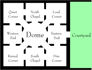
★If our map is largely or entirely set inside a single building, we might want to produce something that resembles a floorplan. It's possible to do this with a little tweaking, like so:
"Baedeker"
Dome is a room. North of Dome is North Chapel. South of the Dome is South Chapel. West of the Dome is Western End. Quiet Corner is northwest of the Dome, north of Western End, and west of North Chapel. Loud Corner is east of North Chapel, northeast of Dome, and north of Eastern End. Eastern End is north of Dim Corner and east of Dome. Dim Corner is southeast of Dome and east of South Chapel. Ruined Corner is southwest of Dome, west of South Chapel, and south of Western End.
The church door is east of Eastern End and west of the Courtyard. The church door is a door.
Index map with
room-shape set to "square" and
room-size set to 60 and
room-name-size set to 9 and
room-name-length set to 13 and
route-thickness set to 20 and
room-outline set to off and
map-outline set to off and
route-colour set to "White" and
room-colour set to "White" and
room-shape of Dome set to "circle" and
room-size of Dome set to 80 and
EPS file.
Now we have a map made of white lines and boxes over a white background, which is not very exciting. If, however, we put a layer of black under this and slightly adjust the room shapes (using an image editor such as Adobe Illustrator), we can produce something that plausibly resembles a floorplan or museum map, like so: